Cuomo issued an order today directing the Metropolitan Transportation Authority to start planning service suspension on subways, buses and trains.
A final decision isn’t expected until tomorrow, but it would mean the beginning of a phase-out at 7 p.m. — including Metro-North and the LIRR.
Everyone leaving the Jets game against Miami in East Rutherford would have service, although a special train from New Haven to the Meadowlands already has been cancelled.
Gov. Christie has declared a state of emergency throughout New Jersey, while United Water began releasing water from its area reservoirs. Some residents said it wasn’t enough.
“I sent my husband to buy cinder blocks to raise our furniture on our first floor — which, by the way, is 6 feet above our driveway,” a Hillsdale resident told CLIFFVIEW PILOT this morning.
“Never in a million years did I think we would have something worse than last year with Irene,” she said.
Christie ordered the levels be lowered last night at Oradell and Woodcliff Lake. New York State officials ordered United Water to lower Lake DeForest in West Nyack — which directly affects Bergen County. Pompton Lake was being lowered, as well — another Bergen priority.
Bergen County officials said they’re prepared to open shelters at the Lyndhurst Senior Center, Bergen Community College in Paramus and Northern Valley High School in Demarest. Pets will be allowed, they said.
- REMINDER: A HUGE help to all of the emergency services out there would be for people to NOT call 911 and police departments to ask when power will be back. Call PSE&G. Irene brought lots of craziness atop the regular medical and domestic violence calls and car crashes. Plan NOW to curb your travel. Before dark tomorrow, get to where you want to be the next several days and stay there.
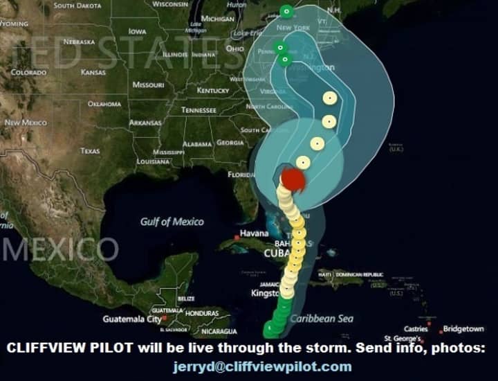
Sandy remained a Category 1 hurricane early Saturday, and was expected to make landfall Monday night near the Delaware coast.
As of this morning it remained a combination hurricane/nor’easter. Although no one can say for sure just yet, it could be worse than Irene.
This is “looking like a very serious storm that could be historic,” Jeff Masters, meteorology director of the Weather Underground forecasting service, told The Weather Channel. “Mother Nature is not saying, ‘Trick or treat.’ It’s just going to give tricks.”
There’s no longer a chance Sandy could head out to sea. In fact, it’s expected to hang a sharp left toward the coast.
Its peak is pegged for Monday night and Tuesday.
A swath of the U.S. several hundreds of miles wide is expected to get continuing gale-force winds at 50 mph, with some areas closer to landfall getting 70 mph blasts. Sandy is expected to stick around two or three days in most areas, with wind damage, power outages and flooding.
“It is a very large storm, a hybrid storm,” added Carl Parker, a hurricane specialist. “The area of strong winds is going to be absolutely enormous by the time it come into the Northeast, and that’s why it is going to be a high-impact system.”
Emergency management officials in Bergen are hoping for 4 to 5 inches of rain and winds at 30 to 40 miles an hour. Of course, it could be much worse.
Christie emphasized the need to be prepared for anything.
“As we move towards what is an increasingly likelihood of seeing Sandy make landfall in New Jersey, I am urging all New Jerseyans to take every possible and reasonable precaution to ready themselves for the storm’s potential impact,” he said.
“That means having an emergency action plan for their families and other loved ones who may require assistance, and avoiding unnecessary risks in the severe weather, including staying off of the roads.”
At the state level, he said, “we are taking immediate steps to prepare for the storm’s impact and ensure that state, local and county governments have the tools they need to manage and respond in a coordinated way.
“With this, government at every level can respond more effectively to conditions on the ground, activate emergency operations plans, and ensure that resources are being marshaled to assist and protect the public through this storm.”
The declaration activates elements of the State Emergency Operations Plan, broadening powers of the New Jersey State Police — including traffic control, limiting access and egress from impacted areas and issuing evacuation orders if needed.
The one bright spot is that this time, unlike last year, New Jersey is better prepared.
“We learned a lot of lessons from Hurricane Irene,” Lt. Gov. Kim Guadagno said during a visit to Hillsdale yesterday “One of the lessons was to follow a set of procedures to prepare for the worst and hope for the best. We’re already engaged in preparing for the worst.”
Click here to follow Daily Voice Rutherford and receive free news updates.


